Much of Burnaby is underlain by glacial till and ice-contact deposits, but low-lying areas near the Fraser River and Deer Lake feature deep sequences of soft, compressible marine clays. These organic silts and peat layers demand careful treatment before any road embankment design can proceed. Without proper ground investigation, fills placed on these soils can settle unevenly or lose stability entirely. A thorough program of field testing — including cone penetration testing to map stratigraphy and plate load tests to verify bearing capacity — helps engineers select the right approach for each site. The goal is a durable embankment that supports traffic loads without excessive post-construction settlement.
For road embankment design in Burnaby, controlling water and achieving uniform compaction are the two factors that separate a long-lasting fill from a maintenance problem.
Service characteristics in Burnaby
Demonstration video
Typical technical challenges in Burnaby
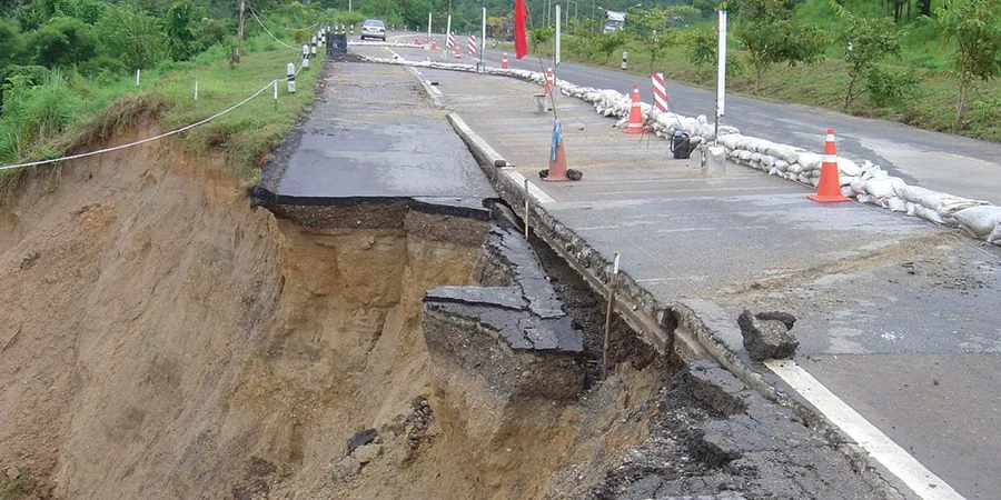
The National Building Code of Canada and British Columbia Building Code set minimum requirements for fills near structures, but Burnaby's geology adds specific hazards. Liquefaction of loose saturated sands is a real concern in the city's eastern neighborhoods during a seismic event. Roads crossing peat deposits can lose 200–400 mm of elevation over a few years if fills are not preloaded. Slope failures along the steep sides of Burnaby Mountain and the Capitol Hill area occur when embankments are built without proper benching or drainage. A detailed risk assessment should look at deep-seated circular failures, differential settlement at the interface of firm and soft ground, and long-term creep in organic soils.
Our services
We offer a full set of services to support road embankment design in Burnaby, from ground investigation to construction oversight.
Geotechnical Investigation and Soil Classification
Boreholes, test pits, and laboratory testing to classify foundation soils and determine shear strength parameters.
Settlement Analysis and Preloading Design
Consolidation testing and numerical modeling to predict long-term settlement and design preloading schedules.
Slope Stability and Drainage Design
Limit-equilibrium analysis of fill slopes and design of subgrade drainage to maintain stability during construction.
Construction Quality Control (CQC)
On-site compaction testing, moisture control, and layer thickness verification to meet project specifications.
Frequently asked questions
What is the typical cost range for road embankment design in Burnaby?
The cost for geotechnical design and testing for a road embankment project in Burnaby typically falls between CA$1.500 and CA$5.950. This range covers field investigation, laboratory testing, analysis, and a design report. Larger projects with multiple fill zones or deep soft soils may increase the fee.
How long does an embankment settlement monitoring program take?
Monitoring usually runs from 6 to 18 months, depending on soil compressibility and fill height. In Burnaby's marine clay areas, settlement plates and piezometers are read monthly until 90% of primary consolidation is achieved.
Can I build a road embankment on peat or organic soil?
Direct fill on peat is risky. Typical solutions include full or partial excavation and replacement with granular material, or using lightweight fill such as EPS geofoam. Preloading with vertical drains also works where peat is less than 3 meters deep.
Do I need a building permit for a road embankment in Burnaby?
Yes. The City of Burnaby requires a development permit for any fill greater than 1 meter in height or that alters drainage patterns. A geotechnical report stamped by a professional engineer must accompany the application.