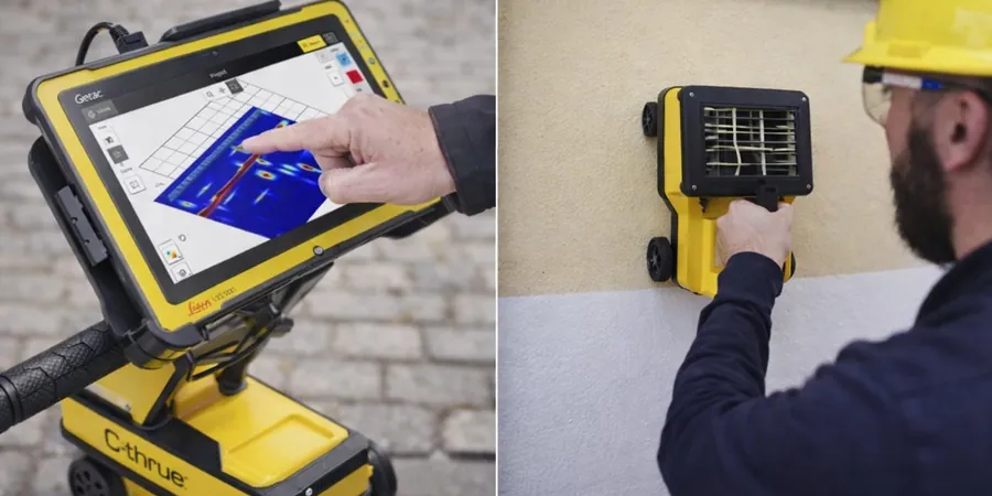
We roll out the GPR unit with a 400 MHz antenna for most jobs in Burnaby — ideal for locating buried utilities before any excavation. The sled-mounted system covers ground fast, and we switch to a 1.6 GHz antenna for concrete scanning on bridge decks or slabs. Every line is georeferenced with RTK GPS so you get clean, X/Y‑tagged radargrams. Before we start, we cross‑reference the site with BC One‑Call records to avoid surprises. The whole setup takes about 20 minutes, then we walk the grid at a steady pace. For deeper targets we pair the survey with calicatas exploratorias to ground‑truth anomalies directly in the field.
In saturated clay near Burnaby Lake, GPR penetration drops to 1.5 m — we adapt antenna frequency and gain settings on site.
Service characteristics in Burnaby
Demonstration video
Typical technical challenges in Burnaby
NBCC 2020 Division B, Article 4.1.2.2 requires that subsurface conditions be investigated before foundation design — GPR is a fast, non‑destructive way to identify buried obstructions, old foundations, or abandoned tanks. In Burnaby, where redevelopment on former industrial lots is common, missing a buried utility or void can stop a job and cost thousands. We flag any anomaly deeper than 0.5 m in the report so the structural engineer can plan accordingly. The method is safe for asphalt, concrete, and green areas with no drilling needed.
Our services
We tailor GPR surveys to the specific site conditions in Burnaby. Choose the option that fits your project stage and budget.
Utility Detection & Mapping
Locate gas, water, power, and telecom lines before you dig. We mark targets in paint or flagging and provide a georeferenced plan. Common for residential infill and commercial redevelopment.
Concrete Scanning
Scan slabs, walls, and bridge decks for rebar, post‑tension cables, and embedded conduits. We use a 1.6 GHz antenna to resolve targets down to 5 cm spacing. Typical for core drilling or saw‑cutting layouts.
Subsurface Void & Cavity Detection
Find voids, sinkholes, or old backfilled trenches under pavement or slabs. Useful for parking lots, warehouse floors, and landfill caps. We deliver depth slices and cross‑section plots.
Frequently asked questions
How deep can GPR penetrate in typical Burnaby soils?
In dry sand or gravel (common along the Fraser River floodplain) we get 3–5 m. In the glacial till of the Capitol Hill area it drops to 2–2.5 m. In saturated clay near Burnaby Lake, expect only 1.5 m. We always pick the antenna frequency based on your target depth and local soil type.
What is the typical cost for a GPR survey in Burnaby?
A standard utility‑detection survey on a residential lot (600 m²) runs between CA$1,730 and CA$2,800. Concrete scanning for a 200 m² slab is around CA$2,400–CA$4,100. Larger commercial sites are quoted per hour or per line‑km. Contact us for a site‑specific quote.
Do you provide the raw radar data along with the report?
Yes. You get the processed radargrams in SEG‑Y and DZT formats, plus a PDF report with plan views, depth slices, and anomaly tables. We also include a KMZ file for GIS integration. All raw data is archived for 12 months.